


Address Management Automation
Address Management AutomationAddress Data and Numbering Automation
Provides Spatial Address Registration System-integrated management of address data for public institutions, distribution companies, infrastructure companies, and local governments.
OverviewExplore
How Address Management Automation Works
Provides Spatial Address Registration System-integrated management of address data for public institutions, distribution companies, infrastructure companies, and local governments.
Address Management AutomationAddress Management Automation
Overview
Address Management Automation: Manage Your Address Management Processes on a Single Platform
Address Management Automation is an address management platform that is fully compatible with Spatial Address Registration System (Turkey's national Address Registration System) and enables address components to be managed in a geographically based and standardized way.
★
Address Management Automation
360°
provides end-to-end digital process management
Address Management Automation is an address management platform that is fully compatible with Spatial Address Registration System (Turkey's national Address Registration System) and enables address components to be managed in a geographically based and standardized way.
♦
Highlights
Map
Thanks to its geographically based structure, it enables all address components (province, district, neighborhood, street, building, independent unit) to be managed on a location basis.
Thanks to its geographically based structure, it enables all address components (province, district, neighborhood, street, building, independent unit) to be managed on a location basis.
0172%
0284%
Format Support
Supports Spatial Address Registration System, XML, SHP, GML, and WFS/WMS data formats.
Supports Spatial Address Registration System, XML, SHP, GML, and WFS/WMS data formats.
0178%
0288%
Detailed Reports
Addresses, streets, buildings, and independent units can be queried, reported, and exported through the system.
Addresses, streets, buildings, and independent units can be queried, reported, and exported through the system.
0184%
0292%
Capabilities
The Address Management Process
Managed from Start to Finish
-
01.Map-Based Main ScreenAddress data is displayed and managed on a geographic map. Users can access address components at the province, district, and neighborhood level; using layer control, measurement, search, and editing tools, they manage all data through the map.
-
02.Cadastral Parcel OperationsAll parcel data is accessed from a single screen. Information such as parcel, block, map sheet, title deed type, and cadastral status is displayed in a list.
-
03.Building Information ScreenStructure and construction information is managed through a single form. Basic information such as the Spatial Address Registration System and National Address Database building number, structure type, class, status, and construction stage is entered.
-
04.Work Order ManagementAll address and street requests are recorded and tracked as work orders. The user can create new work orders, assign them to the relevant person, and update the request status.
-
05.Street Numbering Map ScreenAddress and street numbering data across the province is managed through the map. Building, street, and door numbers are displayed geographically; from this screen, the user can perform editing, querying, and verification operations.
-
06.Street Name RequestNew street name requests are received and managed through this screen. By recording the citizen's information, the current street name, and the requested new name, the approval process is initiated.
-
07.Spatial Address Registration System ReplicationCheck, correct, save, and share your address data against Spatial Address Registration System address data. Coordinate the replication with Spatial Address Registration System data according to the time intervals you choose.
Core Competencies
Modules that support Address Management Automation operations
Provides Spatial Address Registration System-integrated management of address data for public institutions, distribution companies, infrastructure companies, and local governments.
Go to OverviewMap-Based Main Screen
Address data is displayed and managed on a geographic map. Users can access address components at the province, district, and neighborhood level; using layer control, measurement, search, and editing tools, they manage all data through the map.
Cadastral Parcel Operations
All parcel data is accessed from a single screen. Information such as parcel, block, map sheet, title deed type, and cadastral status is displayed in a list.
Building Information Screen
Structure and construction information is managed through a single form. Basic information such as the Spatial Address Registration System and National Address Database building number, structure type, class, status, and construction stage is entered.
Work Order Management
All address and street requests are recorded and tracked as work orders. The user can create new work orders, assign them to the relevant person, and update the request status.
Street Numbering Map Screen
Address and street numbering data across the province is managed through the map. Building, street, and door numbers are displayed geographically; from this screen, the user can perform editing, querying, and verification operations.
Street Name Request
New street name requests are received and managed through this screen. By recording the citizen's information, the current street name, and the requested new name, the approval process is initiated.
Capability Cards
Everything Address Management Requires,
in a Single Platform
The main modules from the documentation were organized into corporate summary cards within the existing page structure.
Map Main
Map-Based Main Screen
Address data is displayed and managed on a geographic map. Users can access address components at the province, district, and neighborhood level; using layer control, measurement, search, and editing tools, they manage all data through the map.
Cadastral Parcel
Cadastral Parcel Operations
All parcel data is accessed from a single screen. Information such as parcel, block, map sheet, title deed type, and cadastral status is displayed in a list.
Building
Building Information Screen
Structure and construction information is managed through a single form. Basic information such as the Spatial Address Registration System and National Address Database building number, structure type, class, status, and construction stage is entered.
Work Order
Work Order Management
The Work Order Management area lets you track, control, and manage the related process from a single screen in line with corporate workflows.
Street Numbering Map
Street Numbering Map Screen
The Street Numbering Map Screen area lets you track, control, and manage the related process from a single screen in line with corporate workflows.
Street Name
Street Name Request
The Street Name Request area lets you track, control, and manage the related process from a single screen in line with corporate workflows.
Address Request
Address Request Application
The Address Request Application area lets you track, control, and manage the related process from a single screen in line with corporate workflows.
Street, Avenue, Boulevard and Square Report
Street, Avenue, Boulevard and Square List Report
The Street, Avenue, Boulevard and Square List Report area lets you track, control, and manage the related process from a single screen in line with corporate workflows.
Resources
Explore our promotional materials
Access presentation and promotional content about Address Management Automation from this area.
Product Tour
Explore Address Management Automation
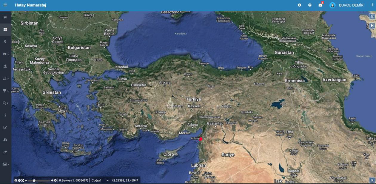
Map-Based Main Screen
Address data is displayed and managed on a geographic map. Users can access address components at the province, district, and neighborhood level; using layer control, measurement, search, and editing tools, they manage all data through the map.
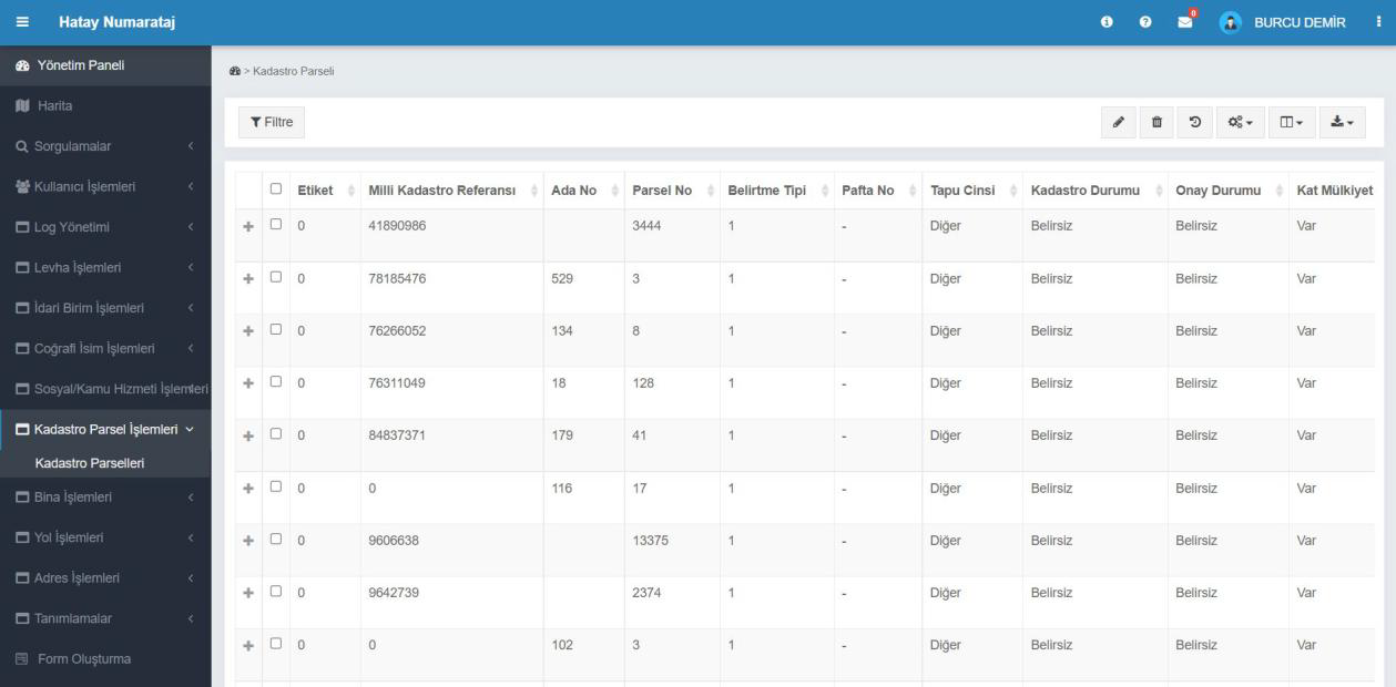
Cadastral Parcel Operations
All parcel data is accessed from a single screen. Information such as parcel, block, map sheet, title deed type, and cadastral status is displayed in a list. Thanks to filtering and editing tools, records can be quickly found and updated.
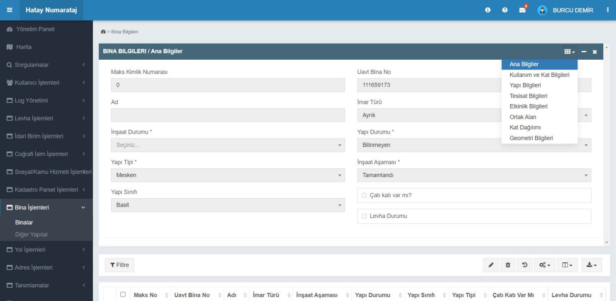
Building Information Screen
Structure and construction information is managed through a single form. Basic information such as the Spatial Address Registration System and National Address Database building number, structure type, class, status, and construction stage is entered.
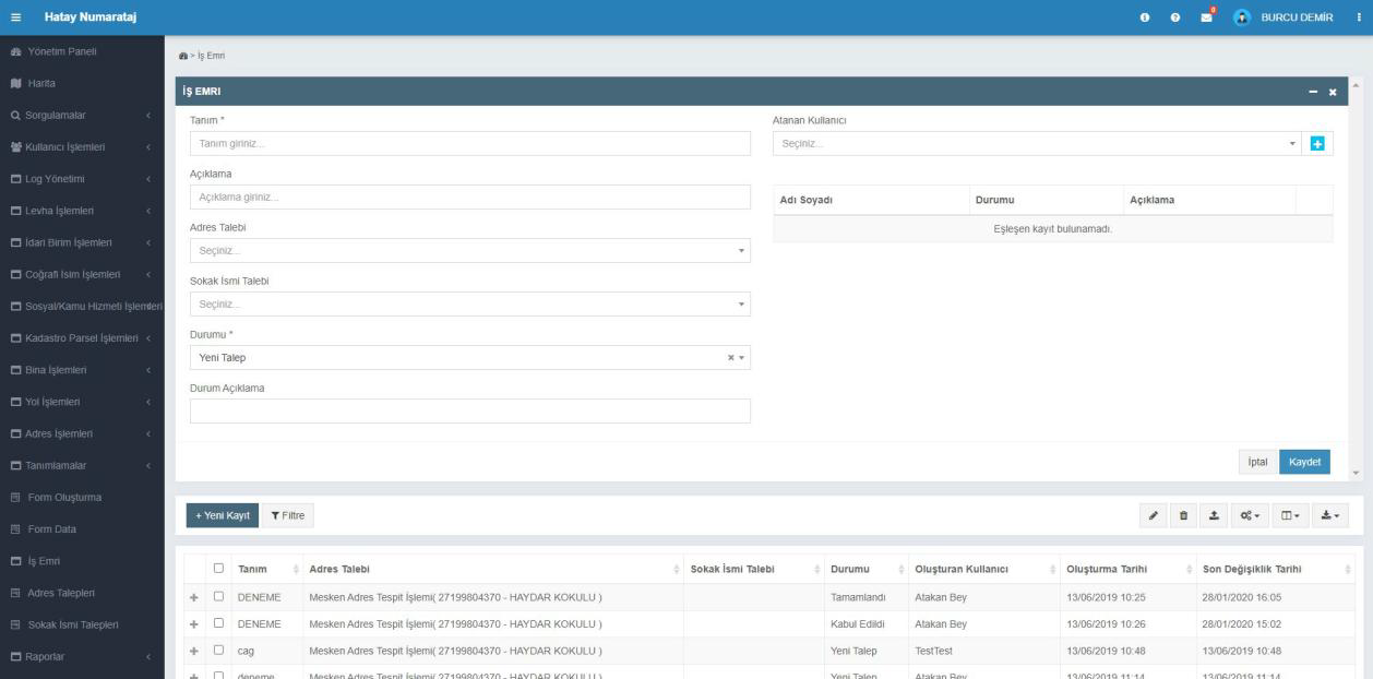
Work Order Management
All address and street requests are recorded and tracked as work orders. The user can create new work orders, assign them to the relevant person, and update the request status.
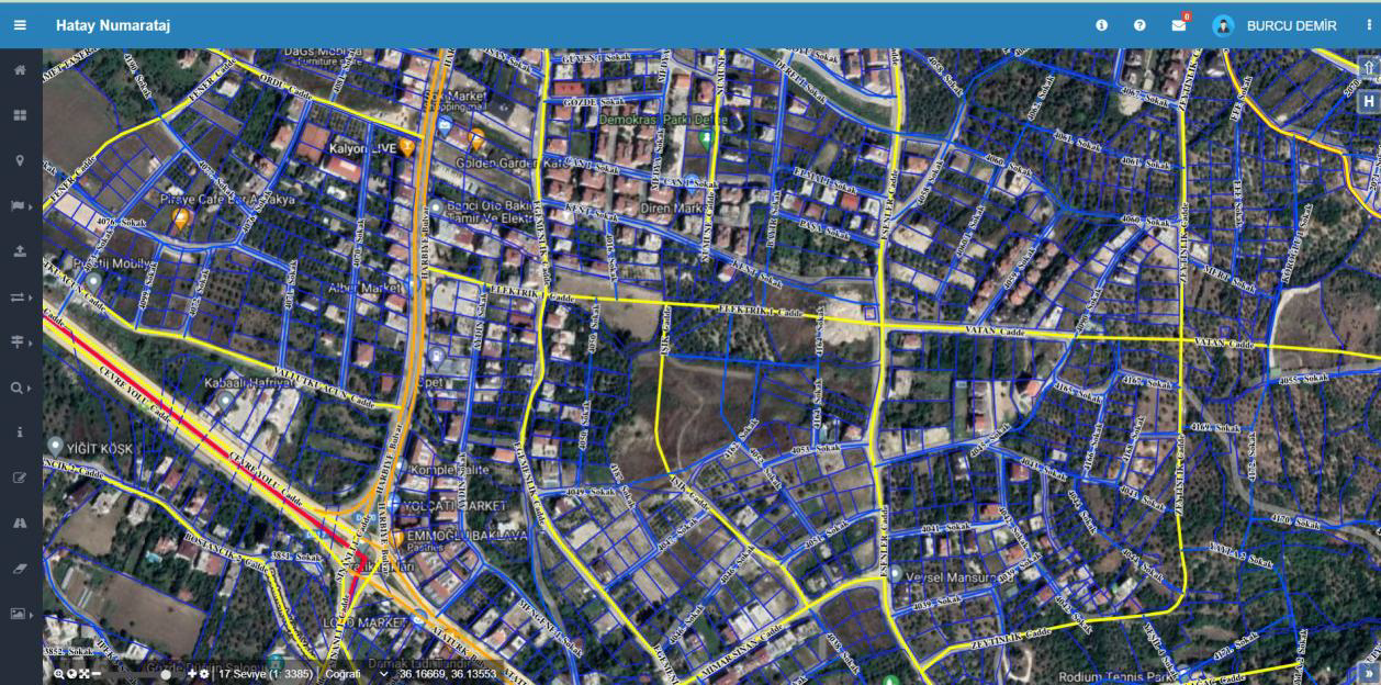
Street Numbering Map Screen
Address and street numbering data across the province is managed through the map. Building, street, and door numbers are displayed geographically; from this screen, the user can perform editing, querying, and verification operations.
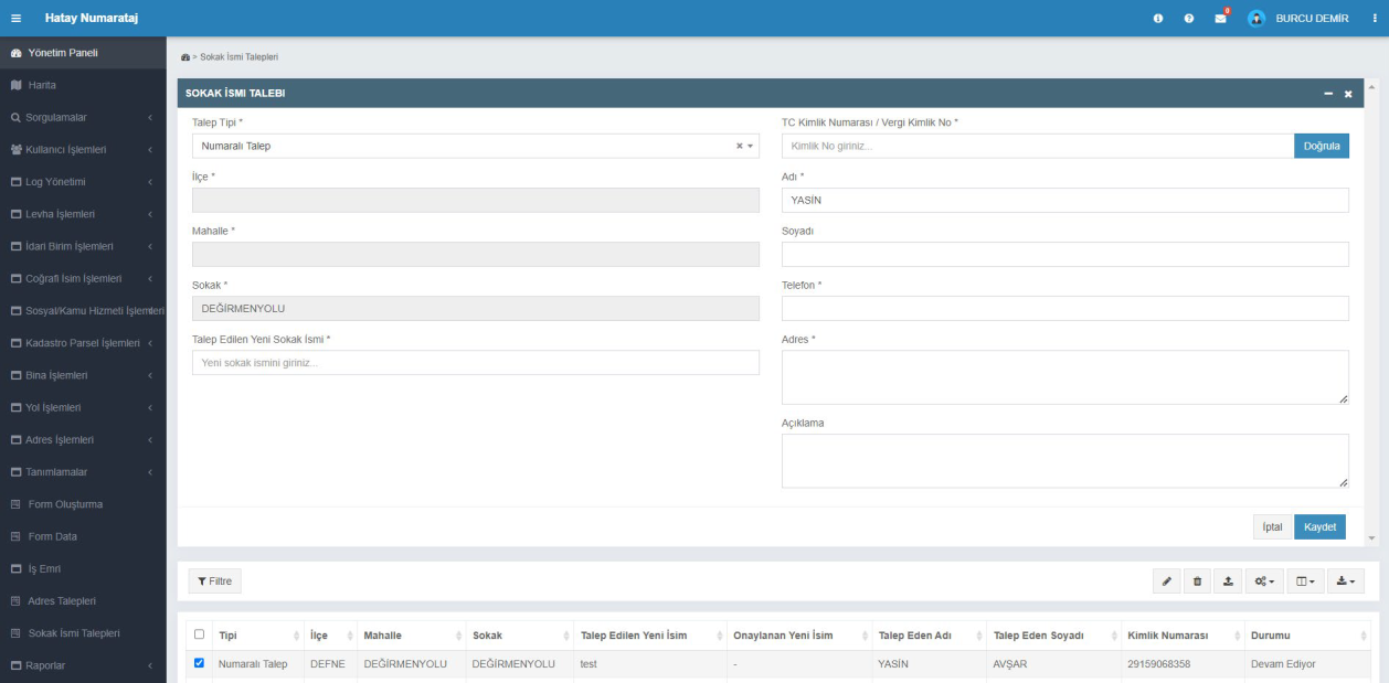
Street Name Request
New street name requests are received and managed through this screen. By recording the citizen's information, the current street name, and the requested new name, the approval process is initiated. All requests are listed in the table below along with their status information.
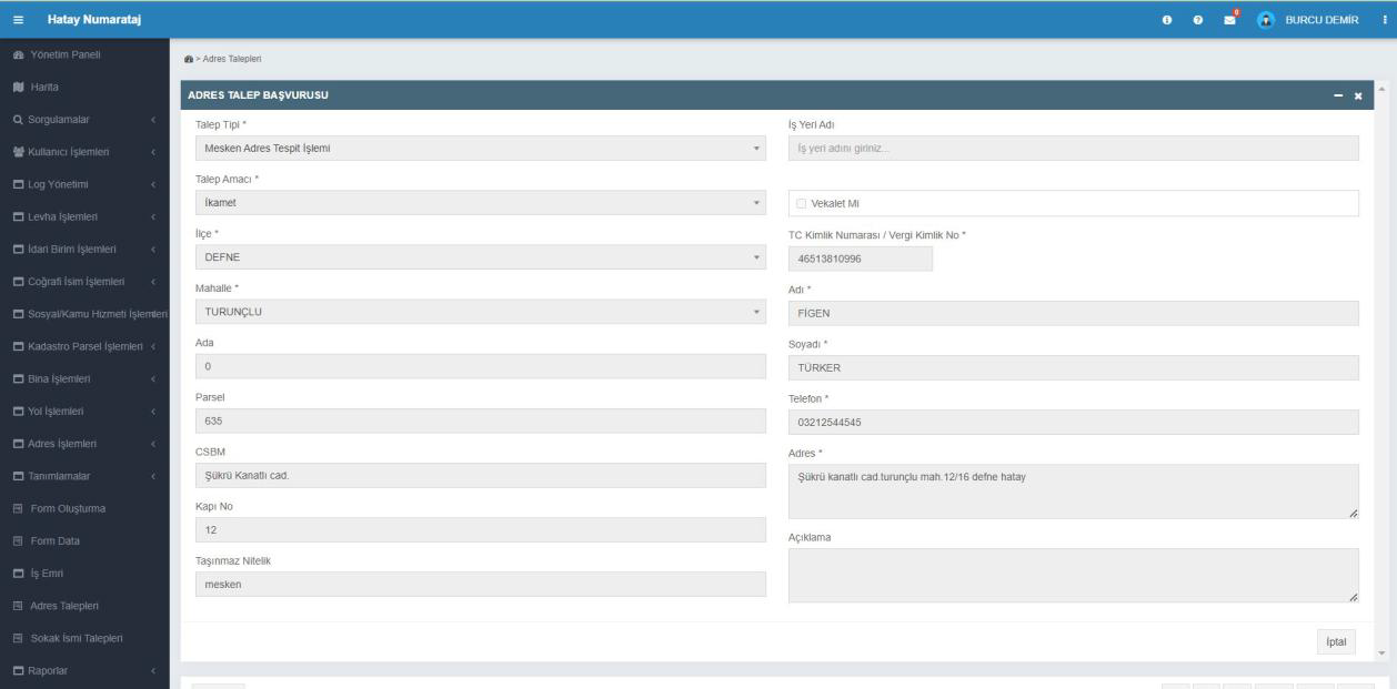
Address Request Application
Citizens submit requests for address determination or new address creation through this screen. The user records the request by entering the block-parcel, neighborhood, building, and contact information. Applications are registered in the system and evaluated by the municipality.
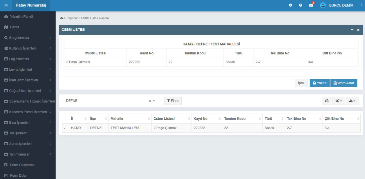
Street, Avenue, Boulevard and Square List Report
Street, avenue, boulevard, and square information is listed on a neighborhood basis. By selecting a district and neighborhood, the user can view the identification code, type, and building numbers; the list can be printed or exported in Word format.
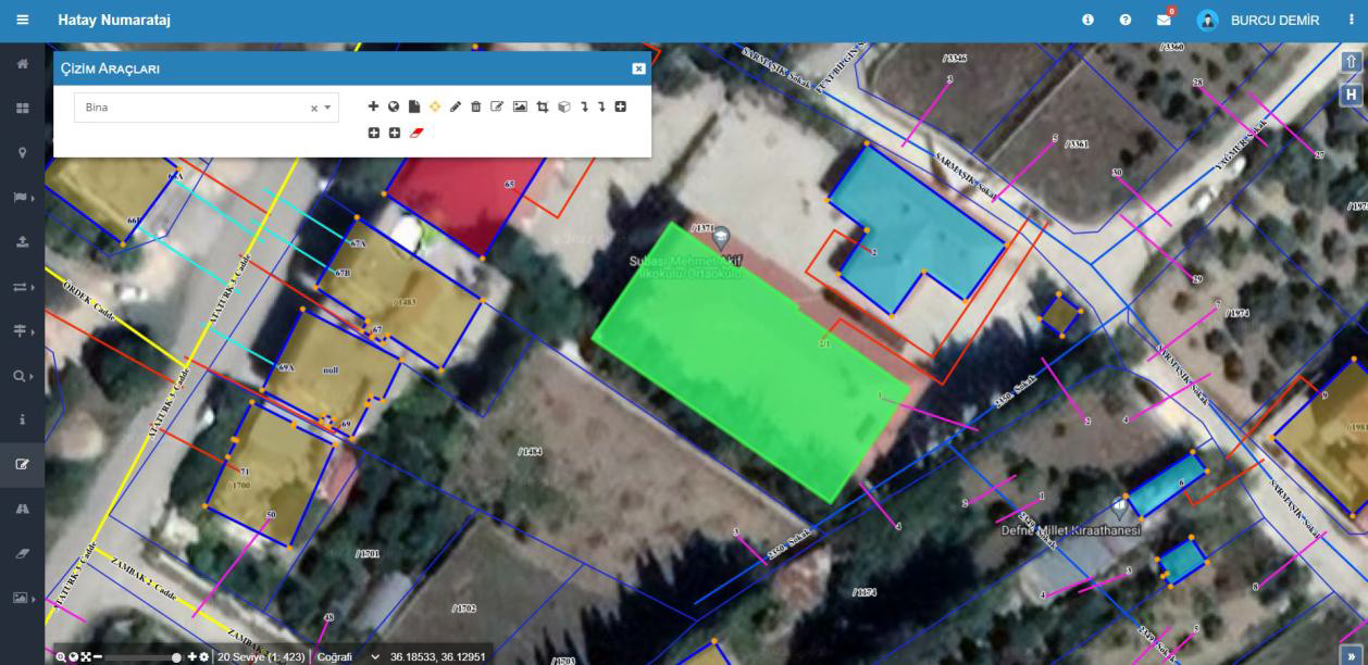
Drawing Tools
The drawing of objects such as buildings, parcels, or streets on the map is done from this screen. By selecting a layer (e.g., Building), the user can perform drawing, editing, and deletion operations. Drawings are instantly applied to the map and saved to the system database.
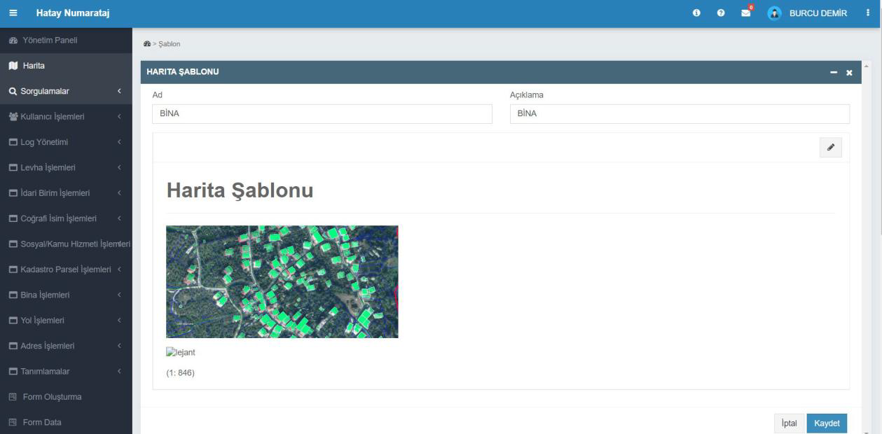
Map Template
Used to arrange different data layers in a single map view. By adding a name and description to the template, the user defines how layers such as buildings, parcels, and streets are displayed. The prepared template is saved and can be used in subsequent operations.
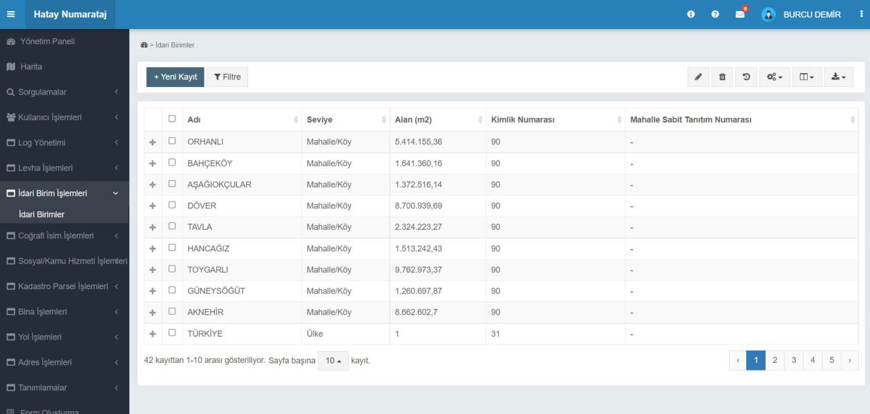
Administrative Units
Administrative areas at the province, district, neighborhood, and village level are managed from this screen. The user can view the name, area, identification number, and level of administrative units, or add a new record.
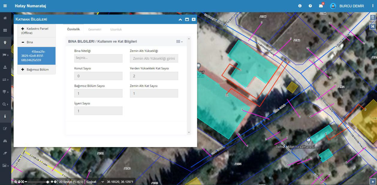
Layer Information
The screen where detailed data for buildings, parcels, and independent units on the map is displayed and edited. The user can update building attributes, floor counts, and usage information directly by selecting them on the map.
FAQ
Quick answers about Address Management Automation
The product's core use cases and corporate contribution are summarized here.
Get in TouchAddress Management Automation is an address management platform that is fully compatible with Spatial Address Registration System (Turkey's national Address Registration System) and enables address components to be managed in a geographically based and standardized way.
Thanks to its geographically based structure, it enables all address components (province, district, neighborhood, street, building, independent unit) to be managed on a location basis.
Addresses, streets, buildings, and independent units can be queried, reported, and exported through the system.
It works fully integrated with Spatial Address Registration System (Turkey's national Address Registration System), Land Registry and Cadastre Information System, Central Civil Registration System, Electronic Document Management System, and qualified electronic signature services.
It complies with the Civil Registration Services Law (Law No. 5490) and the data standards of Spatial Address Registration System (Turkey's national Address Registration System).
Provides Spatial Address Registration System-integrated management of address data for public institutions, distribution companies, infrastructure companies, and local governments.
Address Management Automation
Digitize Your
Processes, Increase Control
Address Management Automation is an address management platform that is fully compatible with Spatial Address Registration System (Turkey's national Address Registration System) and enables address components to be managed in a geographically based and standardized way.
Map
Format Support
Detailed Reports
Integration Compatibility